本帖最后由 独行马 于 2012-12-18 15:09 编辑
大家好,我是马一桦,刚回到温哥华才有时间整理相关资料。
我是83年开始自助
旅行,第一年就去了尚未开发的九寨沟等阿坝高原和
张家界,所以后来再去了一些地方包括黃山都提不起兴趣,直到91年开始往西北跑,那种荒野才使我恢复了生气,
西藏新疆跑遍了,想在什么地方才是人烟稀少的呢,就只有
登山了,因为当时民间还没有登山散户,只有国字号和个别大学才有可能有机会登山,基本上可以说当时我是一个习惯走在潮流前面的人,所以96年底路上遇到的七大古都
攀岩馆是我开始接触登山,尤其是朱发荣和王振华两位老教练的教导令我受益非浅,加上自己之前长期独自旅行养成的冷静行事,才有了之后所谓的成就。
登山中最深刻的一次登山经历?
2000年参加由
贵州登山探险协会组织的宁金抗沙攀登,由于组织混乱,队员自由散漫,类AA制人员水平参差不齐,都想登顶又都不想运输结果是都没有机会登顶,不可能形成先锋与运输人员的相互配合,(当时还没有
阿尔卑斯方式的引入),使我反思,要想攀登成功,就得队伍的构成完善,AA制的弊端也可以通过专职人员的方式得到解决。这一年我从机关辞职,并在2002年尝试用自己培养的队员,自己选择的
山峰,顺利完成玉女峰的首登以及刃脊成立后的一系列首登。
您如何定义自己的身份?职业登山者?
高山向导?高山技能培训师?亦或者是?
有感于九十年代大学登山组织一年一次攀登太少,所以我决定辞职专职干登山,这样一年登山的次数相当于在大学里的近十年,经验积累的更快速有效。可以说2002-2007是职业攀登者,2007年出国之后是自由攀登者。
最自豪的一次登山成就是?
2006年的大黃峰攀登,阿坝州第二高峰,难度也已经超过了我们攀登过的幺峰路线。尤其值得一提的是,
日本人在80年代中国山峰对外开放初期的扫荡时期,这座著名山峰没有被日本人找到,否则就只能象幺峰一样是中国人首登了。这座山是采用的有后援阿尔卑斯方式,由于进山路途较远,大本营之前是由刃脊工作人员协助进入,从大本营开始我和曾山两人完成,大本营之后70%是刃脊路线。这次攀登也得到了2006年度金
犀牛最佳攀登成就奖的肯定。

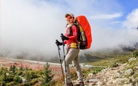
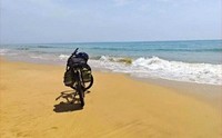
我很少有机会拍自己,这张是幺峰下撤时拆
帐篷,背景陈骏驰等三人正在冲顶
刚注册的微博,新浪搜索:马一桦 ,有问题请前往咨询,我尽量回复。
目前已经回复或跟帖的内容:
第30页
第63页

DAVID ANDERSON & SZU-TING YI
First Ascent of Kameilong 5,873 m – Genyen Massif
Shaluli Shan in West Sichuan Highlands
JAPANESE ALPINE NEWS 2013 ●
In the fall of 2012 a Taiwanese/American expedition spent a month in the remote Shaluli Shan Range
of Western Sichuan, China and came away with the first ascent of Kemailong (5,870 m), a striking
granite tower. On October 1, 2012, Szu-ting Yi and Dave Anderson climbed the 3,500 ft south ridge
to the summit of Kemailong and rappelled the east face returning to their high camp in an 18-hour
push.
This was American Dave Anderson third expedition to the region in the last six years. In October
2006, he and Canadian Sarah Heuniken summited Sachun (5,716 m) a “Patagonia-like” spire and
while American teammates Molly and Andy Tyson climbed Purba (5,685 m). Later that fall, Charlie
Fowler and Christine Boscoff went missing in the same region. After an intense search, their bodies
were discovered in avalanche debris near the base of the area᾽s highest peak Mount Genyen 20,354ft.
In August of 2011, Anderson returned with Szu-ting Yi and Eric Salazar to attempt an unnamed
5,700 m pyramid shaped mountain whose base was covered with tens of thousands of hand placed
rock cairns. The significance of the peak and the rock cairns had been lost over time and was not even
known by the monks at the nearby 600 year old Lengu Monastery. During their attempt on the northeast
ridge of the peak 5,700 m on August 27th, Szu-ting Yi, suffered breathing problems due to a
respiratory infection, contracted earlier in the trip. The trio retreated back to base camp and were met
by several stern looking monks of the Lengu Monastery. The reason for the monks’ displeasure was
not that the peak the climbers were attempting was considered scared. The reason was much more
practical. After Fowler and Boscoff disappeared in 2006 the local Chinese authorities were suspicious
of the Tibetan monks in general and used the tragedy of the missing climbers to inspect the monastery
and search through the monks’ personal belongings.
“The monks just did not want anything bad to happen to us while we were visiting the Genyen region
that would cause the Chinese authorities to come in and bother them,” Anderson summarized. The
monks were happy to have foreigners visit the monastery, take pictures and trek in the valley, but
climbing was out. Initially, Anderson and his team told the monks they were just trekking, but the
monks saw the ice axes and other climbing gear and questioned the climbers further. “Being vague
about our plans in the Genyen region was one thing, but outright lying to the monks was something
that none of us wanted to partake in” , Salazar commented. In addition, the monks voiced their
displeasure with fixed protected and ropes left on Sachun during a 2006 Austrian Expedition.
Anderson, Yi and Salazar opted to leave the valley and head to northeast region of the Shaluli Shan
Range to attempt another peak called Crown Mountain (5,600 m). After a rugged 4 wheel drive they
established a base camp among the nomadic yak herders living below the peak. Crown Mountain
which is 6 miles south east of Xiashe Peak (first climbed in 2005, by New Zealanders Pat Deavoll
and Karen McNeill). They spent the next day establishing a high camp on the north side of Crown
Mountain. Unlike the solid granite Genyen Massif the rock in this area of the Shulai Shan is
composed of extremely loose decomposing rock. Anderson, Yi and Salazar chose to ascend the west
ridge and reached the summit on Sept 3, 2012 after 7 hours from their high camp (IV, 5.6, 50
degrees).
27
In 2012 Yi and Anderson returned with the intension of climbing Kemailong 5,870 m located several
valleys to the north-east of Mt Genyen. The expedition almost ground to halt in the town of Lamaya
when the horse packers discovered Anderson᾽s and Yi᾽s climbing equipment. After a flurry of intense
conversations Yi translated, “Before the bodies of Fowler and Boscoff were discovered on the slopes
of Genyen, the Chinese authorities had imprisoned several of the horse packers merely on the
suspicion that they had something to with the Americans disappearance. As a result the horse packers
were still fearful of helping climbers. To resolve the issue, Yi and Anderson wrote, signed and finger
printed a “waiver” releasing the horse packers from any responsibility if they failed to return from
Kemailong.
Charlie Fowler traveled lightly during his many trips to the Tibetan regions of China, learned to speak
Tibetan, respected the different cultures, always hired local people and the last thing he would have
wanted would be for these same people to be hassled by the authorities, but unfortunately that is
exactly what did happen. I believe, as climbers, we have to be aware of how the consequences of our
actions can negatively affect the native people, because after all we are just visitors.” Anderson
concluded.
During the approach into the mountains Anderson was amazed at the changes that had taken place to
the region in the last six years. New roads and electrical lines now crisscrossed the remote region
which had previously been the domain of only nomads and their yaks.
At their base camp below Kemailong, Yi and and Anderson were challenged by poor weather to even
see a way up the lower section of the peak. Eventually they began shuttling loads up a grueling
1,000 m long boulder field on south side of Kemailong and established a high camp at 5,000 m. On
October 1, a midnight weather check revealed stars instead of the usual fog and hail. At 7:00 am
Anderson and Yi climbed three mixed pitches to gain the saddle on the south ridge of Kemailong.
After three moderate fifth class pitches the terrain became less steep and Anderson and Yi unroped
for 300 meters of easy fifth class climbing. As the ridge narrowed the climbing became more
challenging, but the featured rock kept difficulty under 5.10 for the next three pitches. The rock
continued to improve and the team was able to simul-climb 400 m of perfect rock. More mixed
pitches led to a false summit with the true summit being several rope lengths away past a series of
rock gendarmes plastered with snow. The final pitch started with a stout overhanging hand crack
(5.10) before easing to unprotected face climbing and the summit. By the time Anderson and Yi
summited at 5:00pm, the weather had deteriorated. Gusty winds, hail and electrical discharges zapped
the climbers as they scrambled to get off the summit. Their original plan was to descend the south
ridge, but with all their metal equipment still humming from the electrical storm, Yi and Anderson
decided to bail off the unknown steep 800m east face. The weather continued to deteriorate with
heavy snow compounding the difficulty of finding crack systems to set up rappel anchors. Finally
after leaving most of their rack during 13 rappels Anderson and Yi stumbled back to their high camp
at 1:00am. The next morning, with the weather worsening, they headed down to their base camp,
packed up, and hiked out of the Shaluli Shan Range as the winter season moved in.
The American / Taiwanese team named their route Joining Hands (V, 5.10, M5) for the logistical and
climbing skills Anderson and Yi brought with them to the mountains that when combined allowed
them to succeed in the Shaluli Shan.
“It is an interesting time to be exploring China᾽s Western mountains,” Anderson commented.
“Presently, the Chinese government is pouring money into Western Sichuan᾽s infrastructure.
Improved roads and new airports have dramatically shortened the approach time. While physical
logistics of accessing these areas have gotten easier, weaving through the bureaucracy, nationalism,
● JAPANESE ALPINE NEWS 2013
28
social and cultural diversity of China remains challenging.”
The climbers would like to thank Planet Granite, the AAC Lyman Spitzer Alpine Grant, Patagonia,
Evolve and NOLS for making the expedition possible.

LONG SICHUAN ROUTE ESTABLISHED IN TRIBUTE TO FOWLER AND BOSKOFF
POSTED ON: NOVEMBER 8, 2007
Joseph Puryear
At the end of October, Joseph Puryear and Peter Inglis climbed this route (seen from the southeast) on Peak 5965m in the Genyen Massif, Shaluli Shan, Sichuan Province, China. in honor of Charlie Fowler and Christine Boskoff, who perished nearby. It is likely that the peak has never been climbed before, despite its moderate terrain; the pair roped up minimally for the easy rock and mixed climbing. [Photo] Courtesty of Joseph Puryear
This fall I had the chance to explore a number of mountainous regions of western Sichuan, China. In mid-October, Jay Janousek, Michelle Puryear, Peter Inglis, Julie Hodson and I made our way toward Mt. Genyen (6204m), in the Shaluli Shan Range. Following the extensive research of Tamotsu Nakamura, our objective was the unclimbed peak of elevation 5965m just west of Mt. Genyen, the second highest peak in the massif. Peter and Julie were good friends of Christine Boskoff and Charlie Fowler (who both were killed on Mt. Genyen the previous fall) and wanted to venture into the area to pay tribute to them.
Peter Inglis in the initial couloir. [Photo] Courtesty of Joseph Puryear
After bumping along on a three-day ride by hired van from Chengdu, we arrived at the small town of Sanla, southeast of the Genyen massif. With only a rough map provided by Mr. Nakamura and a picture of his taken from far away to the west, we were able to guess our way up into a hidden, remote valley that concealed the peak's southeastern aspect. Having already acclimatized from earlier weeks of attempting other peaks, we made quick progress and established basecamp within three days, thirty miles beyond Sanla. The trip took us through a vast wilderness, where we made friends with the nomadic people and generally took a step back in time on this distant region of the Tibetan plateau.
We set up basecamp at 4200 meters on October 19. The next day, Peter, Julie and I left for high camp, which we established at 5000 meters, below a glacier on the mountain's southeastern aspect. We climbed high into the basin below the peak to discover--for certain--that we were looking at the mass of rock, ice, snow and hanging glaciers we had set out for.
On October 21, we made an attempt by taking the path of least resistance up an easy glacier south of the peak. We made quick progress but eventually came to a major impasse, where a cliffy sub-summit impeded our progress. We retreated to high camp to scout out an alternate route. In retrospect, we could have ascended an easier route by approaching via the next major valley to the west, but such are the tribulations of first ascents.
We had seen two rocky couloirs (which we had hoped to avoid) that led to the ridge crest on the other side of the sub-summit. One looked easy, one hard. After much thought and discussion, we decided that the easy one didn't go anywhere (in hindsight, a very good assumption). So we decided to take the more challenging couloir. Early the next morning, October 22, Peter and I began climbing. Temperatures were cold, and the weather was unsettled but not threatening. Because of the short days and the length and unknown nature of what was ahead, we mutually decided to solo as much terrain as possible for the sake of speed, which translated to safety. Luckily, most of the chossy gully was frozen in place, and we quickly gained elevation. Just past mid-height, some 5th class rock and moderate mixed climbing provided some entertainment; above, some steep snow led us to the crest of a ridge, which took us to a steep snow headwall and the final east-trending summit ridge. We continued up over a large snow hump and were forced to down-climb exposed 60-degree snow on its backside. This led to a flat col where we took a small break.
Peter Inglis on the final summit ridge. [Photo] Courtesty of Joseph Puryear
We continued up an avalanche chute to the bergschrund below the upper south-facing headwall. Snow conditions on the entire climb had been perfect so we continued un-roped up the 55-degree headwall for about 200 meters to the ridge crest. The summit ridge was quite a surprise; it was very sharp and slightly corniced to the other side--very Alaskan in style. We decided to rope up for a 200-meter traverse to the small summit. We arrived just before noon, said a prayer for Charlie and Christine and began the uneventful descent. We carefully retraced our steps along the summit ridge, down-climbed the headwall, and climbed back to the top of the gully. In the gully we made four double-rope rappels down the steeper sections and downclimbed the rest. We had made the probable first ascent of the peak (moderate 5th class and mixed, ca. 1765m), the second highest peak in the massif. Once back in high camp, we rushed our packing so we might reach basecamp before dark.
The climb was a tribute from all of us to Charlie and Christine. As Peter said to me on the summit, "They died in the most beautiful place in the whole wide world. And we miss them dearly."
We spent another four days trekking, exploring around the north side of Mt. Genyen and visiting the 600-year-old Lengo Monastery before returning to Lamaya. In all, it was a prime ten days with striking mountains, excellent weather and great friends.
Joe Puryear, triumphant, on the summit of Peak 5965m. [Photo] Courtesty of Joseph Puryear